Dales Trails
PENNINE WAY CONQUERED 1990
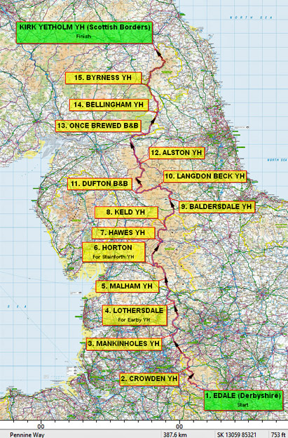
PART 2 - BALDERSDALE TO KIRK YETHOLM
Baldersdale - 135 miles from Edale, 135 miles to Kirk Yetholm - 8 days gone, 7 days to go.
|
Day 9: Baldersdale to Langdon Beck (15 miles)  'CLOSE ENCOUNTERS' I didn't sleep very well at Baldersdale - bad dreams about rabbits! Rabbits were everywhere. They seemed to be using the huge earth dam of Balderhead Reservoir as a warren. I was glad to get away before it gave way. Of course that was after we had cooked and eaten breakfast, prepared our packed lunches and washed up. Diane proudly showed off her latest fund-raising scheme - Baldersdale 'Pennine Way' T-shirts and sweatshirts. We each bought a sweatshirt, but vowed not to wear it until we had finished.

Brian and Gwen tiptoe through the Bluebells By one of the aforementioned stiles we had our first close encounter. Two rather large ladies were in some difficulty. To put it simply they, well one of them, was stuck! There she was on top of the wall unable to move either way. Luckily for her we arrived when we did. Soon we had her down on terra firma on the other side. Then we helped her friend over in no time at all. I have often wondered since about those two large ladies and those awkward stiles. Did they ever reach their destination? Did they ever get back or are they still trapped between the stiles on the south bank of the Tees? 
High Force We had a leisurely lunch break near Low Force, Brian and Gwen basked in the sun on the grassy river bank whilst Mark and I hopped around on the rocks and took photographs. Alas, we had to press on past the series of rapids and small waterfalls that is Low Force. By Holwick Bridge the 'Way' leaves the river bank and enters the Teesdale Nature Reserve, climbing slightly across the heath of juniper. The roar of High Force could now be heard and instinct took me down a path to the right which brought me to the edge of the cliff downstream from the falls. 'It were great'! High Force is England's biggest waterfall in terms of volume and, probably, the grandest. Even in that dry summer it was impressive, perhaps, ironically, thanks to Cow Green Reservoir? Back on the main path, I joined the others at the top of the falls where the water plunges over blocks of dolerite into the pool 70ft below. Gwen was poised as if contemplating jumping across the boiling tumult to the other bank! Not that there was much room on that side. It was a glorious Bank Holiday Monday and the north bank, being adjacent to the road, was crawling with day-trippers. Fortunately for us, crossing points are few so there were few tourists on 'our' side. What is more there is a better view from the south bank and it's free! After more photos it was time to move on, leaving the sightseers and the noise. Once more there was just us and the river, that is apart from the unexpected scar on the landscape called Dine Holm Quarry. Thank goodness it was a holiday and all was quiet. It was on this section where we had close encounter number two: near one of the Nature Reserve's 'You are here' maps stood two rather bewildered elderly ladies. "Can you tell us where we are?" they asked. They couldn't make head or tail of the map so we pointed them in the direction of High Force. They were at least a mile from any river crossing either way. They would at least meet other people near High Force. We still wonder how they came to be at that remote spot. Perhaps Mark was right; he reckoned that they had beamed down from an alien spacecraft!

The Pennine Walkers at Langdon Beck - L-R standing: Myself, Andy, Mel, Maryke, Gwen, Brian & Colin; kneeling: Mark & Alan Langdon Beck Hostel had just been completely refurbished and in fact it was not 'officially' reopened until later in the year. Unfortunately the warden had got his bookings in a muddle; the hostel was full mainly of botanists. He had no record of a booking for Mel and Maryke. Not to worry, we were quite happy to have extra mattresses put down in our rooms, but that was not to be - 'Regulations'. What a contrast to Keld. It was fortunate that they were equipped for camping, so Ann ran them up the road to the camp site at Widdybank Farm. Incidentally, our own Sherpa team were being accommodated at a nearby Outdoor pursuits Centre. However we did all eventually meet up again later in the evening for that essential pint, this time at the Langdon Beck hotel, a grand title for an otherwise ordinary little pub. Day 10: Langdon Beck to Dufton (13 miles)
'NATURAL WONDERS' It was 10 o'clock by the time we got away from the Hostel and headed back down the farm road to rejoin the Pennine Way proper at Saur Hill Bridge. The route heads across fields for about a mile before coming alongside the Tees again near Widdybank Farm. Eleven-year old Hannah had now joined us for the four miles from the bridge to Cauldron Snout and soon was way out in front setting a cracking pace with Gwen. The path hugs the river bank, sections have been board-walked but elsewhere, below steepening cliffs, there are some bad boulder patches to negotiate. We did not like the idea of Hannah returning along this stretch alone but fortunately a solution was at hand in the form of Alan. I managed to communicate between Gwen and Hannah (ahead) with Ann (some way behind) and it was agreed that Hannah would stay with Alan and meet with Ann who would take her car round to the car park at Cow Green Reservoir. With that, Ann set off back to where she had left the car at Widdybank Farm.

Mark at Cauldron Snout Moving quickly on before getting into deep water with the ecologists, botanists and conservationists, we followed the farm road away from the river. We said farewell to Alan; he and Hannah headed off in the opposite direction. We also thought that it was farewell to the Tees, whose glorious company we had shard for about twelve miles, but unknown to us that river had one more surprise in store for us. Past Birkdale there is a steady climb onto featureless moorland. We renewed our acquaintance with peat hags and groughs and, as if inseparable from this terrain, the weather turned to mist and drizzle - mizzle would be a good description - and a strengthening wind swirled across the moors. The 'Way' comes alongside a line of MoD warning signs marking the northern boundary of the Warcop shelling ranges. We came to Maize Beck and crossed over near a limestone outcrop. Gun-fire echoed through the mist. I hoped the shells knew where the boundary line was as well! Away from the beck we headed west through the mist across a plateau of rough moorland grass. We were battling against quite a strong headwind.

High Cup This crag-rimmed hollow drops abruptly from the flat moor to a depth of about 600ft below the moor. A pity about the mist because the books say the Fells of the Lake District are visible straight ahead across the Vale of Eden. The path follows the northern rim of this escarpment before leaving the valley by cutting across the shoulder of the fell down towards Dufton. This becomes a surfaced lane at Bow Hall Farm. Also at the farm was a sign proclaiming 'Afternoon Teas' - too much of a temptation to be passed by, so we turned into the farm yard to be greeted by Mel, Maryke, Colin and Andy, who had, likewise succumbed to the temptation. Balancing camera on a conveniently parked tractor Mark was able to get a good photo of all 8 of us at the picnic tables.
Day 11: Dufton to Alston (20 miles)  'TEES AND TEAS' Just like last night's dinner, Mrs H's breakfast was superb ...and we didn't have any chores to do! So well fuelled for the day ahead we said a greatful farewell and stepped out into a grey, murky morning. It seemed as if we were unwilling to leave behind the comforts of the night before - real food, real beds, blazing fire, TV and tea. We meandered across the village green, leaving Hannah befriending a horse over the fence, past the Stag Inn and we turned down a farm road behind the cottages. The track is followed for about a mile before the business of the day began in earnest - 7 miles of UPS and downs which would bring us onto the highest point of the Pennines. Perhaps we should have been greatful for the mist as it meant that we could only see the immediate challenge, not the whole ridge stretching into the distance.

Mark finds the source of the Tees Cross Fell plateau is encircled by a collar of scree and rocks. We picked our way across this onto the top - and back into the mist. Three of us produced compasses and three of us came up with different bearings to follow. More by luck than judgement we found our way to the trig point amongst the assorted cairns. (In fairness Brian's compass bearing was pretty accurate.) A brisk westerly wind swirled the mist across this barren scene. We huddled behind the stone shelter for the team photo at this, the highest point of our journey, 2,930ft. It was all downhill from here! Well it was for the next few miles anyway. 
Gwen at Cross Fell Trig Point We left the mist on the summit and in sunshine we headed down the old Corpse Road towards Garrigill. All around was evidence of old lead mine workings - ruins and spoil heaps - on which very little grows. Blue-ish crystals of fluorspar, a waste product of the lead mining, were everywhere. We kept our eyes open for good examples of these to take home as souvenirs. For the final two miles the Corpse Road becomes a walled lane between fields of rough pasture. As we rounded the last bend we saw, down below, the car and our Sherpa Team. We had missed the rendezvous for cups of tea these last few days - since Horton in fact - but now they were back. But just a minute, there were others already there ...drinking our tea! We strode down the lane with determination to find Colin and Andy not only drinking our tea, but eating our fruit cake as well! But there was no need to worry; the Sherpa Team had made sure there was plenty of tea and cake for us all. 
Tea and cakes near Garrigill These days Garrigill is an attractive village in a secluded backwater by the River South Tyne, no doubt more peaceful now than in the lead mining times of the 19th Century. The 'Way' follows the river to Alston; a pleasant stroll on a sunny afternoon. Mark even decided that it was now warm enough to change into his shorts. The two of us ambled along, making frequent photo stops and were soon way behind Brian and Gwen. When we arrived at Alston we walked right past the Youth Hostel without realising it was right alongside the path. It is one of the few hostels that can honestly claim to be 'on the Pennine Way'.
Day 12: Alston to Winshields (23 miles)  'THE WALL' The Pennine Way has by now come down off the hills into the valleys, in fact it has ceased following the Pennines altogether. From Alston for six miles as far as Slaggyford it keeps to the valley of the River South Tyne in the company of the river, main road and disused railway. However the route is terribly tedious as the 'Way' tries to avoid the road at all costs. A most straightforward solution, adopted by some walkers, is to follow the track-bed of the railway, but that is cheating, and not for the likes of us!

Taking a break on the Maiden Way - can you spot 11year old Hannah? At Burnstone the route passes under the railway, joins the road (only for a few yards), crosses the stream, passes back under the railway and leaves the road to follow the Maiden Way. Now on this Roman Road, route finding would at least be more straightforward! Form two and half miles it is dead straight, apart from the crossing of Glendue Burn, eventually descending to cross the road again near the site of Lambley Colliery. Here was our Sherpa Tem again. We sat behind a stone wall and had lunch looking across the desolate wasteland that was once Lambley Colliery[27]. Whilst I tried to make the terrain tally with the map and the guide book, Gwen performed emergency blister treatment on Brian's feet. To our right I spotted two figures begin the crossing of this desolate area... Colin and Andy. We watched with interest, then with amusement as they walked, stopped, studied the map, headed left, stopped, headed right and eventually, after more tracking to and fro disappeared out of sight towards Hartley Burn. Surely it was just a simple matter of heading north? No it wasn't! Derelict buildings, crumbling walls, barbed wire and old mineshafts had to be negotiated or avoided in crossing no-man's land. At last we came across Hartley Burn but some way up-stream from the footbridge. Voices hailed us from the trees across the burn - Andy and Colin could see us but we couldn't see them. We crossed the bridge and made our way up through the trees into open farm land. The field ahead was occupied by a herd of cows accompanied by an enormous black bull. He was clearly 'full of the joys of spring' (to put it politely), and we decided that he might not appreciate our intrusion at such a time. So for once we deliberately deviated from the official path and followed a parallel course though the next field. After a couple of farms the terrain reverted to neglected pasture, boggy underfoot and with little evidence of a path. We tracked across this wasteland on a vague compass bearing and came to a section of fence with a single strand of wire for walkers to duck under - just as AW had seen in 1967 - twenty-three years earlier! For some reason, possibly long-gone mine workings, the path follows a big S loop to the west, then east. However the quarries shown on the map as disused appear to be back in use so it was a case of watching out for 'heavy plant crossing'. A track leads down to the A69 Newcastle - Carlisle road, the Greenhead Bypass. We gazed across what appeared to be a vast expanse of tarmac as traffic thundered past; two lanes up the hill, one lane down, with no central reservation. All we could do was wait for a gap in the traffic then run (easier said than done after walking 200 miles). Safely across there were then further hazards to negotiate, namely a golf course and then the Newcastle - Carlisle railway line. Thirlwall Castle looks down on the footbridge spanning Tipalt Burn. From there we followed a walled lane up and round a clump of trees and entered Roman Wall country. Alas for the first mile or so there was hardly any evidence of Hadrian's handiwork - just a ditch and an ordinary stone wall. Further on, at Walltown, a quarry has destroyed all evidence. A picnic site and exhibition centre have been established and here the Sherpas were waiting with afternoon tea. After a well earned break we were faced with a six-mile roller-coaster trek along the line of the wall. To begin with there is very little of the original wall remaining - mostly there was just an ordinary wall built largely of stones from the roman Wall. At last, on Cawfield Crags, we encountered the genuine article, albeit much reduced in height. It was all rather an anti-climax, particularly after having walked 20 miles since breakfast (or 205 miles from Edale). 
Hadrian's Wall Roller-coaster The undulations continued - down at 600ft at Walltown, up to 900ft at Milecastle 44, down 600ft to Burnhead, 800ft at Cawfield and up to 1230ft on Winshields Crag - the highest point on the wall. It was a warm evening, the ground was hard, I was hot, my feet were numb and my knees twinged painfully, particularly on the descents.
At a picnic spot just past Cawfield Crags we came across an ice-cream van - no it was not a mirage - so it was ice-lollies for four. To ease my aches and pains I swallowed a 'brufen tablet, helped down by the ice-cream. A few minutes later, the effect of this lolly/pill combination was amazing and soon I was literally romping along the day's final stretch above Winshields Crag. Gwen was similarly amazed!
Notes:
Day 13: Winshields to Bellingham (17 miles)  'TO THE WOODS' At 10am, after a filling farmhouse breakfast, the Sherpa Team deposited us back at the Wall. There were still more than two miles of the Wall to do before the Pennine Way turned again to the north. This section of the Wall was more interesting, being quite well preserved with its Milecastles. 
Hadrian's Wall - Milecastle No.39 However we declined the optional detour to the most well-known site, Housesteads, and turned away from the Wall at Rapishaw Gap[28]. Ahead stretched the dark green expanse of Wark Forest. By East Stonefield Farm Mel and Maryke had caught us up. We stopped for a breather and I took the opportunity to take a group photograph, I balancing the camera on a wall and using the delay-timer to get myself in the shot. Mel then decided to do likewise. As he was setting his camera the word passed around was - run. Mel triggered the camera and rushed back to his position. As the countdown neared 'zero', the rest of us scattered. The resulting photo showed Mel alone, with glimpses of arms and legs of the rest of us departing the scene. He was not amused!

Farewell to the Sherpa Family: Maisie (my mum), Hannah (my daughter), and Ann (my wife) The Sherpas stood by the roadside and watched us head down the track. One last look back, one last wave, and we disappeared into Wark Forest North. We were on our own again - a relief team would arrive on the last day to get us home, we hoped. Wark Forest North is no different to Wark Forest South, so it is fortunate that the Way only cuts through one corner of it, a distance of about a mile. Then it was across rough grassland before dropping down into the little valley of Warks Burn, then up the other side and across farmland with several stiles and gates to contend with. Near one of the farms we came across a home-made swing fixed to a tree and Gwen couldn't resist having a go. Lowstead Farm has been tastefully restored and looks quite a desirable residence. From there, over a mile along real road, the first road-walking for some time, but we didn't encounter any traffic. At a T-junction our route continues straight on beside a hedge descending to footbridges over Houxty and Soot Burns. The path skirts round Shitlington Hall and heads gradually to another farm below Shitlington Crags. It is a steepish 100ft climb onto the crags. Once on the top there was an opportunity to pause and look back over the farms, to the dark green of Wark Forest, to the Whin Sill Ridge and Hadrian's Wall on the horizon where our day began. 
View towards Bellingham, in the North Tyne Valley Heading north once more, we climbed gradually from the crags onto Ealingham Rigg. A cart-track was followed along the Rigg for about a quarter mile then it was back to rough pasture. The actual line of the path became indistinct and the gate we were heading for was out of sight over the hill. We decided to take a compass bearing from the map and, as usual, Brian, Mark and I each came up with a different figure. We fanned out across the hillside, each following his own course. This time I could claim to be the most accurate as the gate came into view almost dead ahead. Now Bellingham could be seen in the valley but, unfortunately, to get there involved a mile walk along a fairly busy main road which looped round to enter the town across a substantial bridge over the River North Tyne. Then a walk right across town was necessary to reach the Youth Hostel[29].
Notes:
Day 14: Bellingham to Byrness (15 miles)  'CAN'T SEE THE WOODS FOR THE TREES' Considering that we were self-catering we did well to get away by 09.30. The Youth Hostel is conveniently, for today anyway, on the way out of town. Just a quarter of a mile up the hill the 'Way leaves the road and follows a track towards Blakelaw Farm. We passed the farm, gradually gaining height through not particularly attractive landscape - rough pasture, heather and occasional evidence of long-gone mine workings. After about three miles the Otterburn road is reached along the line of an old wagon way which once served quarries and a coal mine - closed in the 1950s. Across the road stretched an expanse of featureless moorland with three insignificant summits; Lough Shaw, Deer Play and Lord's Shaw. At least it was a bright, clear day with cotton-wool clouds against a blue sky. 
Mark, Brian, & Gwen on Lord's Shaw From Deer Play, at 1,183ft, the Cheviot Hills were visible in the distance. We reached the Gib Sneil Road. Byrness is only about 8 miles down the road but by our route it is more than nine. We followed the line of a fence through the heather and bracken over the shoulder of Padon Hill. The summit, with its curious monument is some way to the right[30]. Mark, as ever, decided that a closer inspection was called for and climbed over the fence to battle through undergrowth to the summit. We continued onwards down to the foot of Brownrigg Head where we came across Mel and Maryke taking an early lunch. We waited with them as Mark struggled down the hillside from the monument. As it was a steepish 200ft climb up onto Brownrigg I suggested that we got this climb over with before stopping for our lunch. The others agreed with this so leaving Mel and Maryke in peace, we set off up the hill. Now knowing that water has a tendency to flow downhill, I cannot understand why such a steep slope should have been so wet and soggy, equal to any we had encountered so far, excluding Mark of course. On the top the terrain was flat and ahead sprawled the dark expanse of Redesdale Forest. We stopped for lunch in the shelter of the edge of the forest. This turned out to be the shortest lunch stop of our journey, because, within minutes we were surrounded by voracious flies intent on eating our lunch and us! The only thing for it was to move on and eat on the hoof so to speak. 
Redesdale Forest, showing storm damage We skirted the edge of the forest for about half a mile, and then at a gateway we joined the forest road for the long three miles down to Blakehopeburnhaugh, (the longest place name on the Pennine Way). This stretch seemed never-ending as the road cuts through the forest with only an occasional undulation or slight bend. Every yard of those three miles is identical - just stony road stretching into the distance bordered by thousands of identical conifers. The guide book shows a gate - how I longed for that gate, over every rise, round every bend I prayed that the gate would appear - at last it did. A picnic area has been created in a clearing by the River Rede and we took the opportunity to have a break and a snooze in the afternoon sun ...a pleasant island in a sea of depressing pine forest. 
Taking a break at Blakehopeburnhaugh However we weren't out of the woods yet as it was still two miles to Byrness. The first mile to Cottonshope Burn kept to the bank of the River Rede which distanced us from the forest, but after crossing the river we rejoined the gravel track through the trees. As we neared Byreness the track fords the river, but there is a footbridge for those not wanting to get their feet wet. Myself and Gwen, parading with a giant wild rhubarb leaf as a parasol, took to the bridge whilst the others cooled off their boots in the ford. There are picnic benches here also on a grassy area by the river. On one of those benches two bodies dozed on that pleasant afternoon - Colin and Andy. Gwen decided that they should be woken up - by pouring water over them. Andy sensed her approach and avoided the cold shower, but not Colin. Needless to say this action called for retaliation. Here did they find the energy from to fool around after walking 241 miles? At last it was quits and the pair of them calmed down. The eight of us (we had by now been joined by Mel and Maryke) made our way to the Youth Hostel. This turned out to be the middle two houses in a terrace row, part of a 1930s Forestry Commission Estate which was remote from the rest of the village[31]. Not that there was much to the rest of the village - it only appeared to comprise of a tiny church, a hotel and a petrol station by the main A68 to Scotland.
Notes:
Day 15: Byrness to Kirk Yetholm (26 miles)  'THE LONGEST DAY' From Byrness it is twenty-six miles over the Cheviot Hills and over the Scottish border to Kirk Yetholm (28 miles if you include the detour to the Cheviot Summit itself). It is do or die in one day unless you are equipped to wild camp on the top somewhere, as Mel and Maryke were. However they changed their plans when they realised that this would mean them finishing a day later than the rest of us. They would join us and 'go for it' today, then we would all celebrate our conquest together, or perish together in the attempt.
An early start was essential, so Gwen had us up at twenty past five. The Warden had requested that we don’t get up until seven so as not to disturb other hostellers (all two of them) or the neighbours. At 6.40 am we crept out of the hostel, leaving John to do the washing up and any chores, and to collect our YHA cards from the Warden. All our surplus baggage together with Mel and Maryke's camping gear had been dumped in John's car.

Preparing for the worst at Lamb Hill shelter The conditions were definitely not looking good. Waterproof trousers were dragged from the depths of rucksacks for the first time. So prepared for the worst we moved on - the next shelter was not for 10 miles. The fence again was our guide for the next seven miles as we gradually gained height across the bleak terrain - Lamb Hill 1,677ft; Beefstand 1,842ft; Windy Gyle 2,034ft. Visibility was down to yards, the drizzle became more persistent. The wind whistled across Windy Rig. The drizzle turned to rain which, driven by the winds, soon began to penetrate to parts where rain doesn't normally reach. We came across Colin, Andy and Dave sheltering by Russell's Cairn on Windy Gyle. Also just visible in the mist was a lone soldier standing guard over a jeep! Apparently the Belgium army were on manoeuvres somewhere on these hills. We had no time to search for the lost patrol and with heads down we plodded determinedly onwards. The wind drove the rain horizontally across the desolate wastes. Water was running down my neck, down inside my waterproofs, down towards my boots. This was the first real Pennine Way as described by many writers; not the pleasant stroll that we had experienced up to now (blisters excepted of course!). 
Wind and rain sweep across Windy Gyle The weather was obviously making up for being too good to us for fourteen days and was now throwing everything at us in the last few miles. We plodded on, following a well trodden route on the English side of the fence, although according to AW's Guide we should, by now, be on the Scottish side. In fact we would remain in England until just five miles from the finish. The going under foot was also getting decidedly soggy and some serious bog-trotting became par for the course. We passed Border Gate, where the Roman Clennel Street enters Scotland, and squelched onwards up Cairn Hill (West) at 2,419ft. 
The Border Gate - the weather looks brighter in Scotland At Cairn Hill a decision had to be made - whether to continue for a mile or more across worsening peat bogs to The Cheviot (2,676ft) and back, or to give it a miss and head north into Scotland. An easy choice: Scotland here we come, that is except Mark - of course... and Mel who decided to make the detour and so made the rest of us feel guilty. We watched them disappear into the mist and then turned and followed the fence to Auchope Cairn. It is interesting to note how the border veers away from the Cheviot summit as if the Scots have deliberately avoided any claim to it. On the descent, boardwalks have been provided making the crossing of the peat somewhat easier, although in this weather they became rather slippery. At Hen Hole the other shelter is located. A chance for a break, another brew-up and something to eat. Soon Mark and Mel rejoined us. Their report - the summit of The Cheviot was just like the rest of the ridge, peat, mist and rain. So we hadn't missed anything - no wonder the Scots didn't want it, so no need to feel guilty any more.

Reunited on the road to Kirk Yetholm Believe it or not there is yet another minor summit in that last mile as the road climbs 150ft before dropping down to Kirk Yetholm, which finally comes into view just half a mile from the end. Arm-in-arm, singing 'You'll never walk alone', we strode down the road arriving triumphantly on the green outside the Border Hotel. It was twenty past five on Sunday 3rd June, 1990. There were no flags flying, no brass band playing, no-one: it was all a bit of an anticlimax. As we posed for photographs by the Border Hotel, with Dave doing the honours as photographer, I found it hard to believe what we had achieved. Edale seemed so distant; to have walked 270miles from there in fifteen days didn't seem possible, it had to have been a dream.

Wearing our Pennine Way sweatshirts outside the Border Hotel Kirk Yetholm Those of us with AW's Pennine Way Companion were able to claim our free half-pint (Thanks AW), and all of us obtained a certificate. We signed the visitor's book and noted that Peter from Pudsey had arrived two days earlier. Then it was time to say farewell to Colin and Andy, with whom we had many amusing encounters during those 270 miles. They had a short journey back home to Hexham. The rest of us remained, toasting our success in the true Scottish spirit. Alas the bar ran out of Macallan single malt so we had to change to a lesser brand. At about 11 o'clock we staggered back to the hostel and collapsed into our bunks. It was the end of the day, the last day, the hardest day, longest day. 
Border Hotel Certificate ......
THE END ****************************** POSTSCRIPT The man we met at the gate near God's Bridge on Day 8 turned out to be Ed Geldard, photographer for the book 'Wainwright in the Limestone Dales'. Thanks to some detective work by Mark, I was able to track Ed Geldard down to his studio in Kendal in the spring of 1991 shortly after the book was published, and sadly after the death of Alfred Wainwright at the venerable age of 93.
**************************** |


Arnold Underwood